- Contact Person : Mr. xuejun zhang
- Company Name : Beijing Micropilot UAV Control System Ltd.
- Tel : 86-010-82995388
- Fax : 86-010-82995388
- Address : Beijing,beijing,tiantongyuan 20building 5-4-1 room,Dongxiaokou town,Changping district,Beijing China
- Country/Region : China
- Zip : 100029
UAV Data Processing System


Related Product Searches:UAV Data Processing System,High Quality,Aviation Image Processing Factory, AUTOPILOT,UAV Data Processing System
UAV Data Processing System
— Aviation Image Processing Factory
1. System Introduction
·Oriental Titan company independently research and developed aerospace image processing factory, it is a industrial geography product system that has revolutionary digital processing chain, it product high quality products and superior graphics platform.·With superb handling ability and open architecture, it can automatically deal with large amount of data and a variety of sensors’ original earth observation data, producing f a variety of graphics terminal (digital terrain model, True-Orthophoto, a large range orthographic mosaic image).·Provides an one and only enterprise solutions accord with the situation of China's, with advanced characteristics such as large amount of data parallel calculation, fast and efficiently product graphics data, highly automated production. Standing for the current remote sensing image data processing technology‘s development direction.·Its terminal product can be used for ground data analysis, topographic mapping, city planning, city environmental change monitoring.·Due to specialized hardware configuration (optimized network, computer group, huge stock) and the algorithm corresponding with hardware structure, parallel computing, speed up the production process, will be provide better service to all the field of mapping departments.
2. The Conception of Aviation Image Processing Factory·Independent research and development, it is a data processing system largely produce earth observation data, It can mass production and consists of a series of algorithms, working process and hardware composition‘s composite optimization system.·It contains a plurality of computing node that have powerful computing capacity. Input aerial digital images, satellite images, or conventional optical scanning image, in a small amount of manual intervention conditions, after a series of automated processing, output includes digital surface model (DSM), digital elevation model (DEM), DOM (DOM) and real (TDOM) and other products, and can generate a a series of other intermediate products.1) Digital Surface Model DSM·Titan photo compared with traditional photogrammetric system, One of the advantages is that the digital surface model (DSM) calculation. The traditional photogrammetric system calculated by DSM need artificial estimated elevation information, and "Titan photo" in 25cm to 1m ground sample distance (GSD) between DSM calculated automatically, without manual intervention. Certain photographic measurement system is calculated digital surface model function, but these systems in general work flow, and to mass production of digital products hardware combined very well.
·Upon loading of the image data, Titan photo will use a proprietary algorithm generates a large number of stereo images, and the stereo image pair assigned to the available computing nodes to perform parallel computing, thus reducing the stereo matching process time. According to the multi angle data automatic multiple correlation, can be easily extracted DSM, heading and adjacent to the stereo image pair through multiple correlation method for matching, which is a point-by-point calculation process. Automated algorithms can be obtained from original image every two pixels of the elevation information, finally through the integration of the digital surface model.In addition, the Titan photo system can import and export LAS (LIDAR) format data, therefore on LIDAR DSM and multiple correlation generated DSM mixed.
·DSM calculation is carried out in real shot in the process of calculation is the most important step, only using the digital surface model can be used for orthophoto real firing correction, to ensure that the image of an arbitrary point on the geometric precision.Titan photo and traditional photogrammetric system compared advantage; it is part of the digital surface model (DSM) calculation. The traditional photogrammetric system calculated by DSM need artificial estimated elevation information, and "Titan photo" in 25cm to 1m ground sample distance (GSD) between DSM calculated automatically, without manual intervention. Certain photographic measurement system is calculated digital surface model function, but these systems in general work flow, and to mass production of digital products hardware combined very well.
·After loaded the image data, Titan photo will use a proprietary algorithm generates a large number of stereo images, and the stereo image pair assigned to the available computing nodes to perform parallel computing, thus reducing the stereo matching process time. According to the multi angle data automatic multiple correlation, can be easily extracted DSM, heading and adjacent to the stereo image pair through multiple correlation method for matching, which is a point-by-point calculation process. Automated algorithms can be obtained from original image every two pixels of the elevation information, finally through the integration of the digital surface model. In addition, the Titan photo system can import and export LAS (LIDAR) format data, therefore on LIDAR DSM and multiple correlations generated DSM mixed.·DSM calculation is carried out in real shot in the process of calculation is the most important step, only using the digital surface model can be used for orthophoto real firing correction, to ensure that the image of an arbitrary point on the geometric precision.
2) Semi-automatic Extraction of Digital Terrain Model of DTM3) Extraction of Digital Terrain Model of DTM4) Large-scale Production of Real and Traditional Orthophoto5)Image seamless mosaic and uniform color·Titan photo realize the orthophoto Image Automatic Mosaic, and has strong uniform color function. For the treatment of large area can be reflected more the system of high efficiency and high quality.·For traditional orthophotos, system can be of any spectral band combined with high resolution panchromatic image generating fusion.·Automatic generation algorithm can improve the resolution of multispectral images preserves the spectral information. And Titan photo can be based on image spectrum feature, automatically generate optimal image combination. This means that the fusion algorithm, in the fused image classification does not produce artifacts.
3. The Characteristics of Titan photoTitan photo is the world's first earth observation data automatic processing system, automation, parallel processing, a variety of imaging compatibility, remote management features in one, representing the current remote sensing image data processing technology development direction.
Center Server Processing Platform
·In response to the massive image processing·Multivariate data corresponding to one ·Unified data management and distribution·Accurate data mosaic·"Wisdom" modelThe Perfect Combination of Software and Hardware System Architecture·Titan photo is a set of hardware and software combination, rapid production of solution. Using high performance computes (High Performance Computing) cluster and SAN (Storage Area Network storage area network) architecture.·High performance computing cluster is committed to providing a single computer can not provide a powerful computing capacity and load balancing technology, guarantee, ensure the stable operation of the server.The main advantages of cluster architecture:·Scalability: the computer node and the set of cluster system is highly extensible performance.·High availability: a node in a cluster failure, its task can be passed to other nodes. Prevent a single point of failure.·High performance: load balancing cluster allows the system to simultaneously access the more users.·High cost: can use cheap conform to the industry standard hardware structure of the system of high performance.
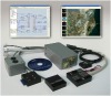
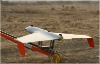
Full Support for the Current Mainstream of Various Aerospace Sensor·Titan photo compatible with current market mainstream Aerospace sensor, can be processed aerial digital images (such as ADS40, UCD, DMC etc.), optical or radar satellite images (such as SPORT5, IKONOS, LANDSAT), and a variety of large aircraft and UAV automatic data imaging function.·Titan photo provides a precise sensor model of the SDK software package, can by adjusting the parameters to adapt to different sensor types, as long as the acquisition of camera parameters and the input system, Titan photo system can recognize and deal with the sensor image. That is to say, the Titan photo system is associated with the sensor is independent of the type of remote sensing image processing system.Powerful Parallel Computation Ability, Automated Processing Capability and Storage Capability·Titan photo using parallel computing technology, greatly improving the processing ability of the system, not only provides more functions, management concurrent workflow, but also on the amount of processing data without restriction.·Titan photo allows a plurality of different types of projects running at the same time, and can automatically arrange production schedule according to plan, make full use of various resources, maximize production efficiency, shorten the project cycle;
Titan photo has a powerful automatic processing technique, than the market on the existing remote sensing image processing software has more automation capabilities, in a small amount of human intervention, can rapidly generate orthophoto and other products. In the entire production process, the system can completely and as much as possible to realize the automatic processing. From the three solutions to the final products such as DSM, DEM, according to plans, processing system automatically assigned tasks, automatic large task into several sub task. Through automated processing, greatly reduce the manual labor, improve working efficiency.·Titan photo digital products in the production process will produce large amounts of data more than the initial intermediate data and the result data, only has a massive online storage capacity, can guarantee the engineering continuous automatic operation. Titan photos use disk array to achieve massive online storage technology, and periodically on the data backup, the maximum possible to avoid accidents caused by the loss of data, ensure the safety of the data.The Improvement of Traditional Algorithm and 200 Kinds of Advanced Algorithm
·Traditional photogrammetric based on each image individually corrected to obtain the orthophoto Image, and then through the mosaic, so that each image parallax minimum. But for Titan photo, Ortho rectification way is just the opposite: Orthophoto above each of the pixels are considered separately, each point is through it in the original image as points combined with it in DSM elevation information to determine. This process is fully automated, is also distributed. It can ensure the ground every point is from the vertical angle (of the high-rise building tilt can be eliminated).·Titan photo has advanced image processing algorithms and many years of accumulation of technology, which represents the current remote sensing image processing technology to the latest development direction.200 kinds of advanced algorithm: sensor calibration, the original image enhancement (atmospheric correction, correction, ionization) fast multi sensor aerial triangulation, rapid automatic generation and remove connection point, automatic extraction of concentrated DSM, real radio correction and traditional geometric correction, automatically by the DTM to automatic generation of contour, mosaic (orthophoto, elevation image and the second generation damascene), image enhancement (local uniform light, contrast, balance compensation etc.).·Titan photo through the establishment of image mosaic plug (SGM) on the existing digital orthophoto mosaic images, rapid update. The processing from the reference database to extract all the required parameters, automatically complete bundle adjustment and radiation correction. The mosaic is spectacularly reduced production time, and with the perfect combination of the original data. This plug-in on satellite images and aerial photograph are applicable, and the production environment (including ground receiving station).
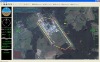
4. Titan Photo Application Case·Empty 3 Homonymy Point Obtain and Optimization·Cognominal point acquisition step by step, error control in the 0.5 pixel.The introduction of sensor parameter modification for reference value; then the king sensor data acquisition overlap area homonymy points; for multiple image data acquisition relative registration correspondence points; finally obtaining the relative registration correspondence points (equivalent to the control point). All correspondence points are given to the elevation value optimization, and visual inspection for the same point in the cloud, water, shadow matching difficult areas, if any, remove them. The last remaining 794 points with the same name.·Ortho rectification·On the basis of a step three results and DSM sensor image and quick view respectively do ortho rectification, corrected image as shown in figure.
UAV Data Processing System